Battlefield Atlas
American Revolution · 1777 Members

Brandywine, 11 September 1777

On 11 September 1777, Sir William Howe's British and Hessian army, advancing on Philadelphia, met George Washington's Continental Army along Brandywine Creek in Chester County, Pennsylvania. While Knyphausen's division demonstrated against the main American position at Chads's Ford, Howe and Cornwallis marched about 17 miles around the American right, crossing the Brandywine at Trimble's and Jefferis' fords, and struck from the north at Birmingham Meetinghouse in the late afternoon. Sullivan's, Stirling's and Stephen's divisions were driven back through Sandy Hollow, Knyphausen forced the crossing at Chads's Ford, and Greene's rear guard south of Dilworthtown held until dark, letting the army retreat to Chester. The largest single-day battle of the Revolution, with roughly 26,000–30,000 men engaged, it opened Philadelphia to the British but left Washington's army intact.

Open the interactive map7 stages on modern satellite imagery and terrain, with 3D elevation

This battle opens with Battlefield Explorer ($9.99 a month on Patreon), which unlocks every battle in the atlas and every one added later. Free battles include Thermopylae, Actium, Hattin, Agincourt, Vítkov Hill, Bosworth, Fort William Henry, Yorktown, Waterloo, The Alamo, Antietam, Little Bighorn, Belleau Wood, Omaha Beach, Inchon, Ia Drang, 73 Easting, Wanat, Baghdad Thunder Runs, Battle of Kyiv, Bakhmut, Avdiivka.
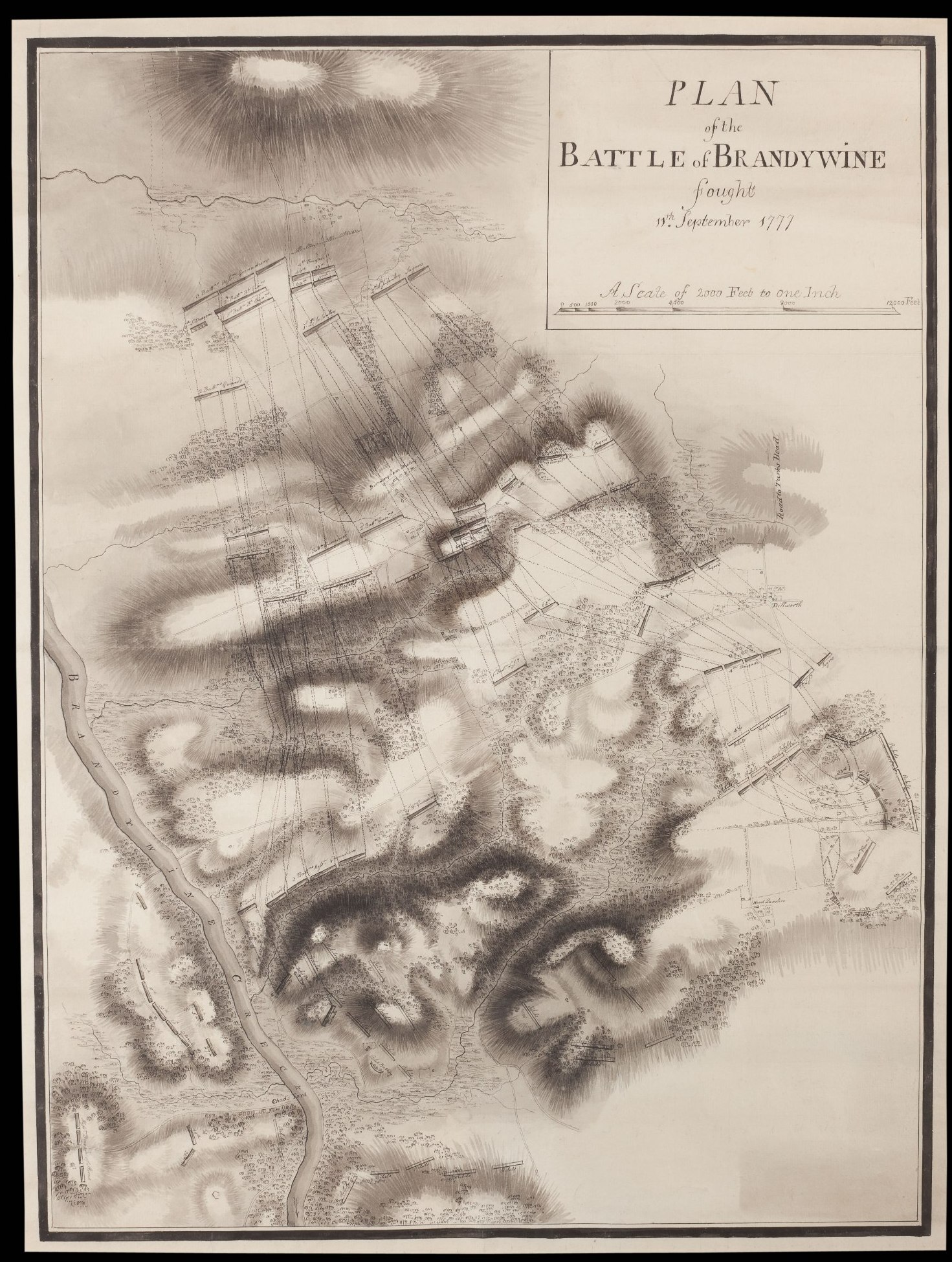
Plan of the Battle of Brandywine
Plan of the Battle of Brandywine — British Army · public domain

The battle, stage by stage

  1. 11 September 1777, about 5 AM

    Two columns leave Kennett Square

    In heavy morning fog, Sir William Howe divides his army at Kennett Square. Lieutenant General Wilhelm von Knyphausen, with roughly 5,000–6,800 British and Hessian troops (accounts differ), takes the Great Road east toward Chads's Ford, where Washington expects the attack. Lord Cornwallis, with Howe riding along, leads the larger part of the army — variously given as 8,000 to 12,000 men — north on back roads to cross both branches of the Brandywine above the American right. Washington's roughly 11,000–15,000 men (Continentals and militia; sources differ) hold the east bank from Pyle's Ford in the south, where Armstrong's militia stand, to Buffington's Ford near the forks. Wayne's Pennsylvanians and Proctor's guns face the main crossing; Greene, Stephen and Nash are in reserve behind; Sullivan holds Brinton's Ford with Stirling behind him, and small detachments watch the upper fords. Maxwell's light infantry are across the creek on the Great Road. Upper-ford and militia positions here are approximate.

  2. About 6–11 AM

    Maxwell's delaying fight; the flank march

    Around 6 AM Maxwell's light infantry open fire on Knyphausen's vanguard — the Queen's Rangers and Captain Patrick Ferguson's riflemen — near Welch's Tavern, then make a stand behind the wall of the Old Kennett Meetinghouse burying ground and along the wooded road past today's Pennsbury markers, before falling back east across the Brandywine. Meanwhile Cornwallis's column, unseen by most American scouts, marches about 17 miles. Chester County's battlefield study times the crossing of the West Branch at Trimble's Ford at roughly 9–11 AM. Through the morning Washington receives conflicting reports about the column, and none reaches him in time to change his dispositions.

  3. About 2–3:30 PM

    Howe on Osborne's Hill

    Knyphausen's guns duel with Proctor's across the creek at Chads's Ford, holding Washington's attention. The flanking column crosses the East Branch at Jefferis Ford (the study times it at about 11:15 AM–2 PM; a 1915-era plaque says 'between 1 and 2 o'clock'), passes Sconnelltown and Strode's Mill, and rests on and behind Osborne's Hill, where by tradition the troops drink tea. Howe directs the attack from this ridge. Washington, now convinced, sends Sullivan, Stirling and Stephen north to meet it; they reach the high ground around the Birmingham Friends Meetinghouse, with Sullivan, who takes overall command, still marching up from Brinton's Ford.

  4. About 4–4:30 PM

    The attack on Birmingham Hill

    Cornwallis's line comes down from Osborne's Hill, across Street Road, through folds of farmland and woods: the Guards on the right, the British grenadiers in the center, the light infantry and the Hessian and Anspach jägers on the left, Hessian grenadiers in support and the 3rd and 4th Brigades in reserve. The Americans face them on the ridge south-east of the meetinghouse: Sullivan's division (de Borre's brigade on the far left), Stirling in the center, and Stephen's Virginians on the right, with a battery on a knoll between Stirling and Stephen. Colonel Thomas Marshall's 3rd Virginia fights forward from an orchard and the walls of the Quaker burying ground. The British right catches Sullivan's division still shifting into line; the Guards and grenadiers drive de Borre's brigade off almost at once. Unit frontages are schematic.

  5. About 5:30–6 PM

    Sandy Hollow and Chads's Ford

    On the hill the fight swings back and forth; tradition says the crest changed hands several times. Stirling's men give way into Sandy Hollow, the narrow defile where the Birmingham Road runs south-east, exposing Stephen's flank; Scott's brigade is driven back, and Woodford's holds until about 6 PM, when jägers work round its right and its guns must be left. Lafayette, newly arrived, is wounded in the leg while rallying troops. The Guards and part of the grenadiers lose their way in thick woods to the south-west. At Chads's Ford, Knyphausen sends his column across at about 5:30 PM; the Queen's Rangers rush Proctor's guns, and Wayne's division, its flank now open to the north, begins to give ground. Greene marches his Virginians about four miles toward the sound of the guns, reportedly in under an hour.

  6. About 6:30–7:30 PM

    Greene's stand south of Dilworthtown

    The retreat streams past Dilworthtown. Greene's division — Weedon's and Muhlenberg's Virginians with Nash's North Carolinians — forms in woods and hedges south and south-east of the village, around the Painter-Craig farm by Delaware County's 2015 study (older tradition puts Weedon's stand in Sandy Hollow itself). Pulaski, with about thirty horsemen of Washington's escort, strikes the leading British troops. Agnew's 4th Brigade and the 2nd Grenadiers, with jägers and guns, attack in the failing light and are checked; Greene holds until dark, then withdraws. Wayne's men fall back east along the Great Road, covered by a brigade and four guns at Painter's Crossroads. Knyphausen halts on the heights east of the ford at dusk.

  7. Night of 11–12 September

    Retreat to Chester

    Darkness ends the battle. The British, after marching some 17 miles and fighting into the evening, halt near Dilworthtown and the Brinton house, stacking captured arms, while Knyphausen holds Chads's Ford. Washington's army retreats, much of it in disorder, to Chester, where it re-forms. Howe's official return gives 93 killed, 488 wounded and 6 missing; American losses, never formally returned, are usually estimated at about 1,100–1,300 killed, wounded and captured, with 11 guns lost. The road to Philadelphia is open: Howe occupies the city on 26 September, but the Continental Army survives to fight at Germantown.

Forces

Howe probably had the larger army, about 15,500 by the American Battlefield Trust's figures against about 14,600 Americans, but published totals for both sides vary by several thousand. Figures for individual units come mostly from secondary summaries of McGuire's order of battle and from the Independence Hall Association's narrative.

British and Hessian (Howe)

Engaged (whole army)The American Battlefield Trust gives about 15,500. Britannica gives about 16,000 and notes that some sources say 10,000. The 1952 PHMC marker at Kennett Square says about 18,000. American Battlefield Trust; Encyclopaedia Britannica; PHMC marker, Kennett Township (HMdb)about 15,500 (about 10,000–18,000)
Flanking column (Howe and Cornwallis)Chester County's eastern battlefield plan gives about 10,000. The Jefferis Ford marker says about 11,000, and the ushistory.org driving tour says about 12,000. Chester County Planning Commission, Eastern Battlefield plan; Jefferis Ford marker (HMdb); ushistory.org driving tourabout 10,000 (8,000–12,000)
Knyphausen's column (Chadds Ford)Kennett Friends Meeting gives about 5,000. The Wikipedia battle article (used here only as a lead) gives about 6,800. Kennett Friends Meeting, Battle of the Brandywineabout 5,000 (5,000–6,800)

Continental Army (Washington)

Engaged (Continentals and militia)The American Battlefield Trust gives 14,600. Britannica gives about 15,000 and notes that some sources say 11,000. Chester County's plan and the PHMC marker give about 11,000. American Battlefield Trust; Encyclopaedia Britannica; Chester County Planning Commission, Eastern Battlefield planabout 14,600 (about 11,000–15,000)
Pennsylvania militia (Armstrong)Wikipedia gives about 1,000 at Pyle's Ford. The order of battle drawn from McGuire gives 2,000 for the division. Treat both as leads. Wikipedia, Battle of Brandywine order of battle (lead; cites McGuire)about 1,000–2,000

Casualties

The British official return lists 587 casualties. American losses were never formally returned and are usually estimated at about 1,100–1,300 killed, wounded and captured. Both sides' contemporary claims about the enemy ran much higher. Certainty: fair.

British and Hessian (Howe)

KilledThe British official list (as given in McGuire) records 93 killed. ushistory.org quotes Howe's report as 90, and Britannica gives 80–90. Encyclopaedia Britannica; ushistory.org93 (80–93)
WoundedThe same figure appears in Howe's return and in Britannica. Encyclopaedia Britannica; ushistory.org488
Missing Encyclopaedia Britannica6
Total casualties (official)The American Battlefield Trust uses 587. American observers and a British adjutant's figure of 1,976 put losses far higher, and ushistory.org thinks Howe underestimated. Modern works generally accept the return. About 40 of the losses were Hessian, per a secondary summary. American Battlefield Trust; ushistory.org587 (587 to about 2,000 claimed)

Continental Army (Washington)

KilledBritannica gives 200–300. Howe reported about 300 killed. No official American return survives. Encyclopaedia Britannicaabout 200–300
WoundedBritannica gives 500–600, and Howe reported about 600. Encyclopaedia Britannicaabout 500–600
CapturedBritannica and Howe's report both give about 400. Many of the captured were wounded. Encyclopaedia Britannicaabout 400
Total casualties (estimate)The American Battlefield Trust gives about 1,300. Greene estimated about 1,200, a Hessian officer 1,300, and an officer in Nash's brigade 700. American Battlefield Trust; ushistory.orgabout 1,300 (700–1,300)

Civilians

Civilian lossesNo civilian deaths are recorded in these sources. Foraging soldiers plundered farms such as Gideon Gilpin's and Emmor Jefferis's, and the Birmingham meetinghouse became a hospital. Gideon Gilpin House marker (HMdb); Jefferis' Ford marker (HMdb)property, not lives

Equipment and ships

American guns lostGreene put the loss at 10 cannon and a howitzer. A secondary summary says the British took 11 of 14 American guns. ushistory.orgabout 10–11

Then and now: how the ground has changed

The northern ground, from Osborne's Hill to Birmingham Meetinghouse and Sandy Hollow, is still largely farmland and preserved open space. The southern and eastern edges of the field, especially along the Route 202 corridor near Dilworthtown where Greene made his stand, are now heavily built over.

The interactive map can show the period landscape (1 shape: Route 202 (Wilmington Pike) commercial corridor) under the units. Open the map.

Weapons

British and Hessian (Howe)

Short Land Pattern musket ("Brown Bess")

Short Land Pattern musket ("Brown Bess")

Smoothbore flintlock musket · 1768–1790s pattern

At Brandywine: Musket of the British regiments.

The British infantryman's musket for most of the 18th century. Accuracy beyond about 100 yards was poor, so the tactics were volleys at close range followed by the bayonet, which the Brown Bess was built to carry.

Caliber
.75 (ball about .69)
Effective range
about 50–100 yd against a formed line
Rate of fire
3 rounds a minute, drilled
Photo: Tower (British Ordnance) · Public domain
Light 6-pounder field gun

Light 6-pounder field gun

Smoothbore muzzle-loading cannon · 18th century

At Brandywine: British light field guns.

The workhorse of 18th-century field artillery: light enough to move with infantry, heavy enough to break up an attack. At close range the gunners switched to canister, a tin can of musket balls that turned the gun into a giant shotgun.

Shot
6 lb iron round shot, or canister
Range
round shot to about 1,200 yd; canister about 300 yd
Crew
about 6–8 men
Photo: Photojunkie · Public domain

Continental Army (Washington)

French Model 1766 musket ("Charleville")

French Model 1766 musket ("Charleville")

Smoothbore flintlock musket · 1766–1777 pattern

At Brandywine: French-supplied muskets armed many Continental regiments.

France shipped tens of thousands of these muskets to the Continental Army from 1777, quietly, before it entered the war. Lighter and slightly smaller-bored than the Brown Bess, it became the pattern for America's first national musket, the Springfield Model 1795.

Caliber
.69
Effective range
about 100 yd
Rate of fire
2–3 rounds a minute
Photo: Charleville Arsenal · Public domain
Light 6-pounder field gun

Light 6-pounder field gun

Smoothbore muzzle-loading cannon · 18th century

At Brandywine: Proctor's artillery at Chadds Ford.

The workhorse of 18th-century field artillery: light enough to move with infantry, heavy enough to break up an attack. At close range the gunners switched to canister, a tin can of musket balls that turned the gun into a giant shotgun.

Shot
6 lb iron round shot, or canister
Range
round shot to about 1,200 yd; canister about 300 yd
Crew
about 6–8 men
Photo: Photojunkie · Public domain

Paintings and photographs

Plan of the Battle of Brandywine
Plan of the Battle of Brandywine An 18th-century plan of the battle, showing the flank march and the attack at Birmingham. British Army · public domain · source
Birmingham Friends Meetinghouse
Birmingham Friends Meetinghouse Birmingham Friends Meetinghouse (1763), used as a hospital by both armies; its burying-ground wall formed part of the first American line. National Park Service · public domain · source
Gideon Gilpin House
Gideon Gilpin House The Gideon Gilpin House in Brandywine Battlefield Park, plundered by foraging soldiers after the battle. Kmdevoe · CC BY-SA 4.0 · source

Free for everyone every year on its anniversary: September 11.

Accuracy score: 70/100 (good)

How the accuracy score works

Sources and method

Brandywine, 11 September 1777. Fixed points from the Historical Marker Database (hmdb.org): the 1915 Pennsylvania Historical Commission tablets at Birmingham Meeting House, Osborne's Hill, Sconnelltown, Trimble's Ford and Dilworthtown; the PHMC markers at Kennett Square ('the British Army divided here') and on Wilmington Pike ('the battle ended just southwest of here'); the Sandy Hollow, Birmingham Hill, Peace Garden, Jefferis Ford, John Chads House, Chads springhouse, Ring House, Gilpin House, Barns-Brinton House, Pennsbury (Maxwell) and William Brinton 1704 House markers. Timings and staging from the Chester County Planning Commission, Brandywine Battlefield technical report (2010, ABPP-funded KOCOA study) and Eastern Battlefield strategic landscapes plan; Greene's stand from Delaware County Planning Department, Strategic Landscapes Preservation Plan: Rearguard Defense and Strategic Retreat (2015). The Birmingham Hill line follows Michael C. Harris, 'Battle of Brandywine: Proving the Patriots' Mettle' (American Battlefield Trust, Hallowed Ground, 2017), and Harris's Brandywine (2014); organization and strengths follow Thomas J. McGuire, The Philadelphia Campaign, vol. I (2006), as summarized in secondary references. Strengths and casualties: American Battlefield Trust (15,500 v. 14,600; 587 v. about 1,300), Encyclopaedia Britannica, and the Independence Hall Association's ushistory.org narratives and driving tour. Brandywine Battlefield Park (Pennsylvania Historical and Museum Commission) and its self-guided tour. Unit frontages are schematic; the upper fords, Pyle's Ford, Knyphausen's deployment and Greene's exact line are approximate, and the times of the flank march and the Chads's Ford crossing differ between sources.

Where the positions come from

Further reading