Battlefield Atlas
American Revolution · 1775 Members · from $3

Lexington and Concord, 19 April 1775

On 19 April 1775 General Thomas Gage sent about 700 British grenadiers and light infantry under Lieutenant Colonel Francis Smith and Major John Pitcairn from Boston to destroy military stores at Concord. Warned by riders, Lexington's militia stood on their town green at dawn; shots were fired, who fired first is still disputed, and eight Americans were killed. At Concord's North Bridge about 400 militia drove off the bridge guard in the first deliberate American volley of the war. On the march back the column was attacked along the road for miles and was saved at Lexington only by Lord Percy's relief brigade of about 1,000 men with two cannon; the combined force fought its way through Menotomy and Cambridge to Charlestown by dusk. Some 1,700 regulars and, over the day, perhaps 3,500 to 4,000 militia took part. British losses were 73 killed, 174 wounded and 26 missing; American losses 49 killed, 39 wounded and 5 missing. The day began the Revolutionary War and the siege of Boston.

Open the interactive map8 stages on modern satellite imagery and terrain, with 3D elevation

This battle opens with Battlefield Enjoyer ($3 a month on Patreon), which unlocks every battle in the atlas and every one added later. Free battles include Thermopylae, Siege of Alesia, Hattin, Agincourt, Vítkov Hill, Bosworth, Fort William Henry, Yorktown, Waterloo, The Alamo, Antietam, Little Bighorn, Belleau Wood, Omaha Beach, Inchon, Ia Drang, 73 Easting, Wanat, Najaf.

The Battle of Lexington (Doolittle, 1775)
The Battle of Lexington (Doolittle, 1775) — Amos Doolittle — public domain

The battle, stage by stage

  1. 18–19 April 1775, 10 PM to 2 AM

    The alarm

    General Thomas Gage sends Lieutenant Colonel Francis Smith with the grenadier and light infantry companies of the Boston garrison — about 700 men, with Major John Pitcairn of the Marines — to seize and destroy the province's military stores at Concord, about 18 miles away. From about 10:30 PM Navy boats ferry them across the Back Bay to Lechmere Point in East Cambridge; they wade ashore through a marsh, 'wet up to the knees' by Lieutenant John Barker's diary, and wait on a muddy road until about 2 AM for provisions. The plan is no secret. Paul Revere is rowed past HMS Somerset to Charlestown and rides by way of Medford; William Dawes goes out over Boston Neck. Both reach the Hancock-Clarke House in Lexington, where John Hancock and Samuel Adams are staying, and ride on with Dr. Samuel Prescott. A British mounted patrol takes Revere on the road in Lincoln; Dawes turns back; Prescott jumps a wall and carries the warning to Concord. Lexington's company musters on the Green around 1 AM. (The riders are shown for context only.)

  2. 19 April, about 5 AM

    Lexington Green

    Captain John Parker's Lexington company — 77 men by the usual count, though estimates run from about 60 to British guesses of 200 or 300 — stands in two ranks on the north part of the Green, near the road to Bedford and away from the road to Concord, more a show of resolve than a barrier. Pitcairn's six light infantry companies come up the Cambridge road; the leading companies pass north of the meetinghouse and form a line, while Pitcairn rides around the south side, ordering the militia to lay down their arms. Parker, by his own deposition, orders his men to disperse and not to fire. Then a shot rings out. Who fired first is disputed and probably can never be known: nearly all the American depositions say the regulars did; Pitcairn reported shots from behind a wall, Barker that the militia fired first, and Lieutenant Edward Gould that he could not say. The regulars fire volleys and charge without orders. Eight Lexington men are killed and ten wounded; one regular is wounded and Pitcairn's horse is hit. Smith comes up with the grenadiers, restores order, and marches on to Concord.

  3. About 7 to 9 AM

    The search at Concord

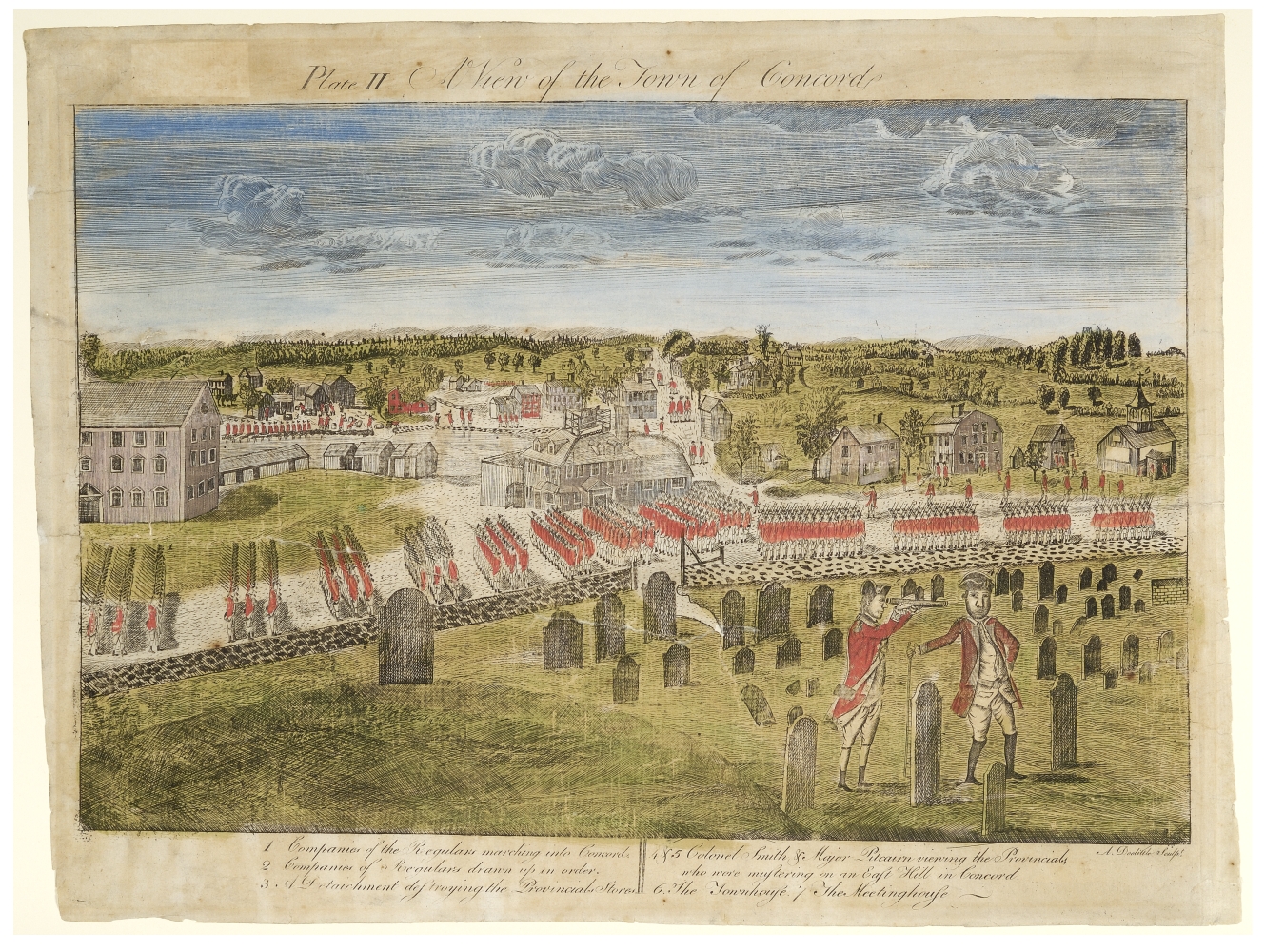
    The regulars enter Concord about 7 AM, light infantry on the ridge, grenadiers on the road; the militia fall back across the North Bridge to Punkatasset Hill. Smith and Pitcairn use the Wright Tavern as headquarters while the grenadiers search the town. Captain Mundy Pole guards the South Bridge; Captain Walter Laurie holds the North Bridge with three light companies, about 96 men, while Captain Lawrence Parsons takes four companies, about 120 men, two miles on to Colonel James Barrett's farm. Warned in time, the Barretts have moved or hidden the stores, and the province's cannon are already gone; the soldiers find nothing. In town the regulars dump flour and shot into the millpond and burn gun carriages and entrenching tools. Meanwhile companies from Acton, Bedford, Lincoln and other towns join Concord's men on the Muster Field above the bridge, nearly 400 in all, minute companies on the right and militia on the left, and Laurie's companies fall back toward the bridge.

  4. About 9:30 AM

    The North Bridge

    Smoke rises from the town center, where the fire from the burning gun carriages has spread to the town house. 'Will you let them burn the town down?' Lieutenant Joseph Hosmer reportedly asks. Colonel Barrett orders an advance, not to fire unless fired upon, and the column marches two abreast down to the bridge with Captain Isaac Davis's Acton minute company at its head and Major John Buttrick in command. Laurie's companies pull back across and crowd into a column on the east bank. A few British shots splash into the river, then a ragged volley, apparently without orders, kills Davis and Abner Hosmer. Buttrick shouts 'Fire, fellow soldiers, for God's sake, fire!' The exchange lasts only minutes: the regulars lose three killed or mortally wounded and nine wounded, and break back toward the town, meeting Smith's slow-moving grenadiers. The militia do not pursue. Parsons's companies return from the Barrett farm over the bridge unmolested. The Rev. William Emerson watches from the Old Manse.

  5. About 12:30 to 2:15 PM

    The Battle Road

    About noon Smith starts back for Boston, with flankers out along the ridge north of the road. At Meriam's Corner, where the ridge ends and the column must close up to cross a small bridge, the Reading, Billerica and Chelmsford companies open fire, up to 1,100 militia by one count; from here on the Americans attack. Sudbury and Framingham men join near Brooks Hill. At Elm Brook Hill, the 'Bloody Angle', Major Loammi Baldwin's Woburn men fire from the high ground east of the brook and others from the west, catching the regulars 'between two fires'; at least eight are killed there by one militiaman's count. Bedford's Captain Jonathan Wilson is killed near the Hartwell farms. At the Lincoln line Parker's Lexington company, in a wooded, boulder-strewn position that recent battlefield archaeology places just north of the traditional outcrop, fires into the column from close range: 'Parker's Revenge'. On Fiske Hill Smith is wounded in the leg, an officer is thrown from his horse, and the column, nearly out of ammunition, begins to break.

  6. About 2:30 to 3:30 PM

    Percy's relief

    Brigadier General Hugh, Earl Percy, has marched from Boston at about 9 AM by Boston Neck, Roxbury and Cambridge with the 1st Brigade — the 4th, 23rd and 47th Regiments and the 1st Battalion of Marines, about 1,000 men — and two 6-pounders. He forms his brigade on the high ground about half a mile east of Lexington Green and opens his ranks for Smith's exhausted men, who fall down 'with their tongues hanging out of their mouths', as one British account later put it.Percy reported meeting them 'about 2 o'clock'; most modern timelines say nearer 3. His guns scatter the militia for a while, one ball passing through the meetinghouse, and his men burn houses near the village. The Munroe Tavern becomes his headquarters and hospital. Earlier, the 'old men of Menotomy' had captured one of his supply wagons. The positions of the four regiments within Percy's line are schematic.

  7. About 4:30 to 5:30 PM

    Menotomy

    Percy resumes the march about 3:30 PM with Smith's men at the head of the column, the 23rd as rear guard and flankers out on both sides. Brigadier General William Heath and Dr. Joseph Warren join the militia, whose numbers keep growing as companies arrive from farther towns. At the Foot of the Rocks and through the village of Menotomy (now Arlington) the fighting is the heaviest of the day: militia fire from walls, orchards and houses, and the flankers break into houses and kill those they find inside. Jason Russell and about eleven others, many of them Danvers men, are killed in and around his house, the most killed in any one place that day; Jabez Wyman and Jason Winship are killed in Cooper's Tavern. Samuel Whittemore, 80, is shot, bayoneted and left for dead, and lives. By the Arlington Historical Society's count about 40 regulars are killed and 80 wounded in Menotomy, and 25 Americans killed and 9 wounded.

  8. About 6 to 7:30 PM

    Charlestown Neck

    At Watson's Corner in Cambridge the flankers trap a party of militia, killing several. Rather than take the right-hand road through Cambridge toward a bridge where militia are waiting,Percy takes the road to Charlestown over Prospect Hill, his guns firing again. As dusk falls the column crosses Charlestown Neck and forms on Bunker Hill under the guns of HMS Somerset; Colonel Timothy Pickering's Essex militia reach Winter Hill too late to block the way, and Heath halts the pursuit. The fighting has covered some 16 to 18 miles of road. Gage's return gives British losses as 73 killed, 174 wounded and 26 missing; the Americans lost 49 killed, 39 wounded (41 in some counts) and 5 missing. By morning thousands of militia ring Boston, and the siege of Boston has begun.

Then and now: how the ground has changed

The Battle Road between Lexington and Concord is still a country road through fields, woods and old farmhouses, because the National Park Service has spent decades restoring it. Around the park, though, the farm towns of 1775 are now suburbs, the main road has been widened and rerouted as Route 2A, and the North Bridge is a 1956 replica.

Weapons

British

Short Land Pattern musket ("Brown Bess")

Short Land Pattern musket ("Brown Bess")

Smoothbore flintlock musket · 1768–1790s pattern

At Lexington and Concord: The grenadier and light infantry companies and Percy's brigade carried the Land Pattern musket.

The British infantryman's musket for most of the 18th century. Accuracy beyond about 100 yards was poor, so the tactics were volleys at close range followed by the bayonet, which the Brown Bess was built to carry.

Caliber
.75 (ball about .69)
Effective range
about 50–100 yd against a formed line
Rate of fire
3 rounds a minute, drilled
Photo: Tower (British Ordnance) · Public domain
Light 6-pounder field gun

Light 6-pounder field gun

Smoothbore muzzle-loading cannon · 18th century

At Lexington and Concord: Percy's two 6-pounders covered the retreat at Lexington.

The workhorse of 18th-century field artillery: light enough to move with infantry, heavy enough to break up an attack. At close range the gunners switched to canister, a tin can of musket balls that turned the gun into a giant shotgun.

Shot
6 lb iron round shot, or canister
Range
round shot to about 1,200 yd; canister about 300 yd
Crew
about 6–8 men
Photo: Photojunkie · Public domain

American

Short Land Pattern musket ("Brown Bess")

Short Land Pattern musket ("Brown Bess")

Smoothbore flintlock musket · 1768–1790s pattern

At Lexington and Concord: Militia carried muskets of many patterns, many of them British.

The British infantryman's musket for most of the 18th century. Accuracy beyond about 100 yards was poor, so the tactics were volleys at close range followed by the bayonet, which the Brown Bess was built to carry.

Caliber
.75 (ball about .69)
Effective range
about 50–100 yd against a formed line
Rate of fire
3 rounds a minute, drilled
Photo: Tower (British Ordnance) · Public domain
American long rifle

American long rifle

Rifled flintlock (Pennsylvania / "Kentucky" rifle) · about 1730–1840

At Lexington and Concord: A few riflemen; most militia fought with smoothbore muskets.

Made by German-American gunsmiths in Pennsylvania for hunting on the frontier. The spiral rifling and a greased patch around the ball made it far more accurate than a musket, but slow to load and too delicate for a bayonet, so riflemen fought as skirmishers and sharpshooters rather than in the line.

Caliber
typically .45–.54
Effective range
200–300 yd in skilled hands
Rate of fire
about 1 round a minute
Photo: Long rifle of William Clark · Missouri Historical Society · Public domain

Paintings and photographs

The Battle of Lexington (Doolittle, 1775)
The Battle of Lexington (Doolittle, 1775) Amos Doolittle's 1775 engraving of the shooting on Lexington Green, made from interviews soon after. Amos Doolittle — public domain · source
The British in Concord (Doolittle)
The British in Concord (Doolittle) Doolittle's view of the British officers surveying Concord while the town is searched. Amos Doolittle — public domain · source
Percy's relief at Lexington (Doolittle)
Percy's relief at Lexington (Doolittle) Doolittle's engraving of the British retreat through the south part of Lexington, with Percy's brigade and guns. Amos Doolittle after Ralph Earl — public domain · source
The North Bridge
The North Bridge The reconstructed North Bridge, where the militia first fired on the regulars by order. Phillip Capper — CC BY 2.0 · source
The Lexington Minuteman
The Lexington Minuteman The Minuteman statue on Lexington Green. GlennB33 — CC BY-SA 4.0 · source

Free for everyone every year on its anniversary: April 19.

Accuracy score: 76/100 (good)

How the accuracy score works

Sources and method

Lexington and Concord, 19 April 1775. Fixed points come from the waysides and place pages of Minute Man National Historical Park (National Park Service): the North Bridge, the Muster Field, Fiske Hill, the Paul Revere capture site, Elm Brook Hill / Bloody Angle and the British grave, the Old Manse and the Barrett farm, and from the Historical Marker Database (hmdb.org) for Lexington Green (Minuteman statue, 1799 Monument, Line of the Minute Men, Buckman Tavern), the North Bridge statue and Battle Monument, Meriam's Corner, the Brooks area, the Minute Man Visitor Center, and in Arlington the Old Men of Menotomy, Samuel Whittemore and Cooper's Tavern markers; the American Battlefield Trust's heritage-site pages give the Hartwell Tavern, Wright Tavern, Meriam House, Munroe Tavern, Hancock-Clarke House and Jason Russell House. The layout of Parker's line follows the National Register nomination for the Lexington Green (the line from the boulder near Bedford Street to the 1799 Monument) and the reading of the depositions in Emerging Revolutionary War; the meetinghouse site and several road traces are approximate. The timetable follows the NPS April 19, 1775 timeline and casualty totals, the NPS article The Embattled British Column (Percy's 1st Brigade, order of march and two six-pounders), the NPS North Bridge questions page (Laurie's 96, the 400 militia, the casualties), Parker's Revenge: Lexington's Lost Battlefield and the Friends of Minute Man National Park archaeology (77 men on the Green), the NPS Elm Brook Hill page, the Concord Chamber of Commerce Battle Road hour-by-hour account (after the Boston National Historic Sites Commission), the Arlington Historical Society's Events of April 19th (Menotomy losses), the Cambridge Historical Society on the Lechmere Point landing and route, the Old Concord DAR's account of Concord, and the William L. Clements Library's Bloody Work (Gage papers; 49 killed, 39 wounded, 5 missing). Contemporary accounts: Percy's report to Gage of 20 April and Pitcairn's of 26 April (Teaching American History), Lieutenant John Barker's diary, Ensign de Berniere and the American depositions of April 1775. David Hackett Fischer, Paul Revere's Ride (Oxford University Press, 1994), is the standard modern narrative. Figures are as attributed: Smith's force is usually given as about 700 (some accounts 800 or more), Percy's as about 1,000, Parker's company as 77, and American wounded as 39 or 41. Who fired first on Lexington Green is unresolved. Images: Amos Doolittle's 1775 engravings (public domain).

Where the positions come from

Further reading