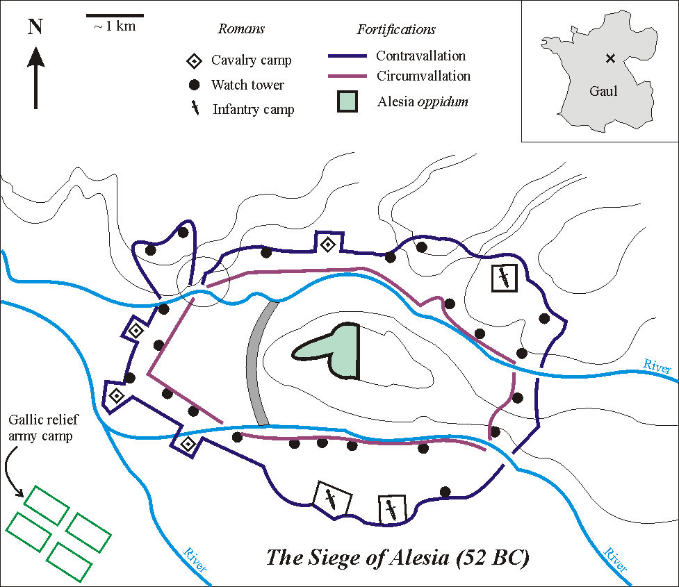
Siege of Alesia, 52 BC. Ancient accounts. Caesar,
Bellum Gallicum 7.68–90 — the only near-contemporary account, by the victor, written to present his own generalship (McDevitte and Bohn translation,
7.67–82 and
7.79–90): the site, the 11- and 14-mile lines, 23 redoubts, the traps, the Mandubii, the relief army's quotas (8,000 cavalry, about 240,000 infantry), the cavalry battle, the night attack under Antony and Trebonius, the camp of Reginus and Rebilus on the northern hill, Vercassivellaunus's 60,000, Labienus's six and 39 cohorts, Caesar's cloak, the 74 standards and the surrender. Plutarch,
Caesar 27 (about 150 years later: 300,000 relief, 170,000 in the town, the surrender in armor); Cassius Dio,
Roman History 40.41 (early 3rd century AD: Vercingetorix kneels; executed after the triumph).
Archaeology. M. Reddé and S. von Schnurbein (eds.),
Alésia: fouilles et recherches franco-allemandes sur les travaux militaires romains autour du Mont-Auxois (1991–1997) (Paris, 2001; reviewed by N. Hanel,
Bonner Jahrbücher 204); M. Reddé,
Alésia: l'archéologie face à l'imaginaire (2003); Ministère de la Culture,
'The Alesia question' (Napoleon III's Commission de topographie des Gaules, 1861–1862, and its
Album des fouilles); DRAC Bourgogne-Franche-Comté,
archaeology brochure on Alesia (the Gallic camp on the eastern slopes near Les Celliers);
Encyclopædia Universalis, 'Alésia' (traps identified on the ground, towers every 15–17 m, the inscribed sling bullets of Labienus, the 97-hectare plateau, the 1992
murus gallicus); D. B. Campbell and others,
Roman Army Talk (only camps A, B and C, perhaps G, of Napoleon III's eight confirmed; fort '4 bis' on the plain).
Reference and site. Encyclopaedia Britannica, 'Battle of Alesia'; J. Lendering,
Livius.org, 'Alesia (52 BCE)';
The Past, 'Asterix's legacy at Alésia' (MuséoParc, LiDAR, camps on the Montagne de Flavigny); Hérodote.net on the
MuséoParc and on the
site debate (André Berthier's Chaux-des-Crotenay thesis; Reddé's camp at the foot of Mont Réa).
Positions. Camp and site points from
vici.org (61937, 61940–61942, 4389, 4390; after Napoleon III's plan as redrawn by Oehler); Mont Réa from komoot; the MuséoParc from its Gîtes de France listing; the statue's coordinates from Wikipedia. The two Roman lines, the camp outlines, the oppidum outline and the troop blocks are schematic: the excavation plans were not available in machine-readable form, and the lines were not continuous everywhere. Strengths are given as attributed ranges; dates in the pre-Julian calendar of 52 BC are approximate. Images from Wikimedia Commons.